Welcome to Michigan Lakes!
We are all about Michigan lakes. Life on, in and near Michigan's lakefront brings a richness that rewards for a lifetime. Have a story or comments on your experience? You can be one of the first to share it with the world on our Michigan lake directory.
- Error
Saginaw Road Trip FEB 13 09
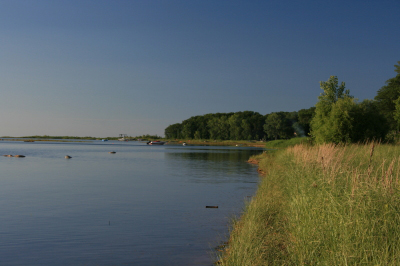
If the Lower Peninsula is shaped like a left-handed mitten, then Lake Huron is a lobster claw clamping onto the thumb of that mitten, and the Saginaw Bay is the claw’s smaller, bottom part. I was standing at lands-edge in a small park along State Road 25 somewhere between Caseville and Port Austin, near the joint of the claw, watching the sun lower toward the silvery sereneness of the bay.
I’ve always had a bit of a Gypsy in me. I suppose it’s got something to do with my Austrian blood, but I’m wired with an innate curiosity that can propel me hundreds of miles in search of what lies over the next hill and around the bend. On this day, I had chosen to observe our nation’s birthday by exploring a part of America with which I was unfamiliar, a part of my own, beloved home state that I hadn’t seen before. I’ve ranged freely throughout the west, central, southeast, and northern parts of Michigan, as well a through much of the Upper Peninsula, but today I planned to finally turn my attention to the vast flatlands of the thumb.
And flatlands they are, the flattest land you’ll find anywhere north of the Illinois prairies. Stretching along the Lake Huron shore from Oscoda down through Bay City and then back up again to Grind Stone City, and inland as far west as Hersey Township, down to south of Howell, and arcing back northeast through Livingston, Oakland, Lapeer, Sanilac, and Huron Counties, the Saginaw Bay watershed occupies nearly 8,700 square miles. Not only is it the largest drainage basin in Michigan, but it’s also the largest contiguous freshwater wetland system in the United States. That means flat. It also means muck farms and other agriculture, and it means great habitat for migrating songbirds and waterfowl along the Mississippi Flyway.
I had no idea how flat, flat really was until I headed east beyond Bay City, and then north toward the shoreline road. That, friends, is some mighty level territory. But it was the lakeshore that I really wanted to see.
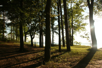
Winding my way along State Road 25 past campgrounds and resorts, I found myself in the midst of some very pretty coastal forests. After a long afternoon of driving, I was ready to stretch my legs and get close to the water. A roadside park beckoned, and I pulled in and parked the car. A beautiful, shady little open woods awaited me, with the afternoon sun slanting in from over the lake and casting long shadows on the ground.
I lingered for half an hour by the shore, enjoying the view up and down the coastline and watching the sun slowly descend like a radiant balloon toward the great, shining bay. Then I hopped in my car and began the long journey back home. By the time I reached Flint, darkness had enfolded the land in its warm summer cloak, and fireworks filled the sky in every direction. It was a lovely and colorful ending to an enjoyable day. But in the words of Robert Frost, I still had miles to go before I slept.
The thumb region is, as I’ve mentioned, the part of Michigan that I’m least familiar with, and one I’d like to explore more from an outdoors perspective. Do you know of any nature preserves, state parks, or places in this region that possess outstanding beauty or natural features? If so, I’d love your suggestions. Please drop a note in the comments section and tell me where in the thumb area you would visit next time around if you were me.