Welcome to Michigan Lakes!
We are all about Michigan lakes. Life on, in and near Michigan's lakefront brings a richness that rewards for a lifetime. Have a story or comments on your experience? You can be one of the first to share it with the world on our Michigan lake directory.
- Error
Big Wind over the Big Lake July 3 09
Storm season came late to Michigan this year. An inordinately cool spring kept the big weather in check longer than usual, but it did finally arrive, and I welcomed it with open arms. As a storm chaser, I look forward to the first spring storm the way a kid looks forward to Christmas. I love stepping outside under balmy, bright skies, sniffing the year’s first exhilarating fetch of good Gulf of Mexico moisture, and watching nicely sheared cumulus towers pile up through the troposphere and morph from benign little cotton puffs into war-like giants. Man, how I love a good storm, don’t you?
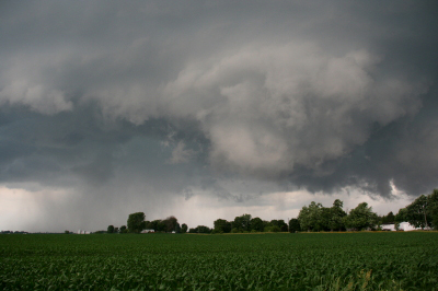
Storms in Michigan come in a few basic varieties, with some kinds being more common than others. The wall cloud in this picture is a sight you’ll rarely see in our neck of the woods. Once in a while, though, when conditions are right, you may encounter one. Most folks would just as soon not. It’s a sight that sends storm-wise Midwesterners scurrying for their basements, as a tornado can develop out of such a cloud in a matter of moments.
A wall cloud often—though by no means always—forms in the part of a thunderstorm that appears to be the least stormy. To the north, rain and even hail may be falling, while the wall cloud itself descends from a rain-free cloud base on the southwest, rear part of the storm. Just behind it and to the south, the sky may be clear and the sun may be shining. Don’t let that fool you! This is the business end of the storm, the part that is greedily ingesting massive amounts of the warm, moist air that fuels a thunderstorm the way gas powers an automobile engine.
The wall cloud pictured above was shot from a distance of maybe half a mile. The whitish area in the foreground was rotating vigorously and moving directly toward my storm chasing partner, Bill, and I at around 35 miles an hour. We stayed in our location long enough to snap a few photos, then skedaddled. The storm never put down a tornado during the time that we tracked with it—the surface winds weren’t right. Had they shifted to the southeast, though, I think things would have gotten considerably more interesting in a hurry.
Here’s a tip: if a thunderstorm is moving toward you and you can feel a warm wind rushing into it (not a cool wind blowing out of it), watch out. Trouble is very likely headed your way.
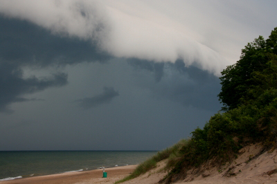
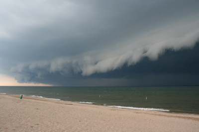
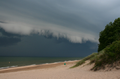
In contrast to a wall cloud, an arcus cloud (or shelf cloud) usually looks a lot more menacing than it really is. It’s a much more common cloud formation than a wall cloud. You’ll find it at the front end of an advancing thunderstorm; it’s a low, wedge-shaped structure that looks all the more threatening for the black skies that follow directly behind it. Like a wall cloud, a shelf cloud shows motion. However, a wall cloud will exhibit vertical rotation, like a giant carousel, while a shelf cloud’s motion is primarily lift, and any turning will be horizontal, like a huge rolling pin.
Look for quiet air as an arcus cloud approaches—the proverbial calm before the storm—then a cool, brisk breeze that builds and builds, sometimes to as high as 60 or 70 miles an hour, and rarely even faster. Once you begin to feel that wind, you’d better be heading for shelter if you haven’t found it already, because the rain that follows is usually a soaker of the first order.
Watching a good thunderstorm roll in is always a worthwhile experience. But it’s a doubly impressive sight on the Lake Michigan shoreline, with lightning bolts flickering on the horizon and thunder grumbling in the distance as the glowering shelf cloud steamrolls toward you across the sky. Next time stormy weather threatens to end your fun at the beach, don’t be too quick to leave. Stick around. The show is about to begin, and you don’t want to miss it.